Top 10 Free GIS Certifications & Courses to Explore in 2026
The geospatial sector continues to evolve rapidly. GeoAI, cloud GIS, spatial data science, digital twins, Earth observation and enterprise GIS are changing the skills expected of GIS professionals. Keeping those skills current is therefore becoming just as important as traditional cartography and spatial analysis.
The good news is that developing GIS expertise does not always require a significant training budget. A growing ecosystem of free courses, tutorials and learning resources provides opportunities for students, professionals and organisations to strengthen their geospatial capabilities.
Top 10 Free GIS Certifications & Courses for 2026 highlights learning opportunities across several important areas.
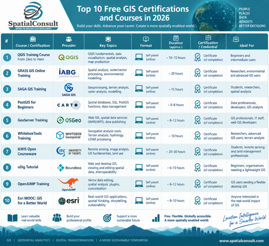
For anyone starting their GIS journey, QGIS training provides an excellent introduction to mapping, spatial data management, visualisation and analysis. More experienced practitioners can explore GRASS GIS and SAGA GIS, which provide sophisticated capabilities for raster processing, terrain analysis, environmental modelling and advanced geoprocessing.
However, modern GIS increasingly extends beyond desktop applications.
Learning PostGIS introduces the fundamentals of managing and querying spatial information within a relational database environment. These skills become particularly valuable when designing enterprise GIS architectures or working with large geospatial datasets.
Similarly, GeoServer introduces GIS professionals to web-based geospatial services and standards such as WMS and WFS. Understanding how spatial information is published and consumed through interoperable services is becoming increasingly important as organisations move toward integrated, web-based geospatial ecosystems.
Remote sensing and Earth observation skills are another valuable area for development. Combining satellite imagery with GIS allows professionals to investigate environmental change, infrastructure, land use, agriculture, climate and many other spatial phenomena.
There is also an important career lesson here: don’t focus exclusively on collecting certificates.
A certificate can demonstrate continuous professional development, but the real value comes from being able to apply what you learn.
Build a PostGIS database. Create a QGIS analysis workflow. Publish spatial data through GeoServer. Automate a repetitive GIS process. Develop a web map. Analyse satellite imagery. Document the results and add the project to your professional portfolio.
That practical experience can often demonstrate far more than a certificate alone.
Free learning resources provide an excellent opportunity to start building those capabilities.
🌐 Learn. Experiment. Apply. Share.
Which GIS, GeoAI or spatial-data skill are you planning to develop in 2026?
#GIS #Geospatial #GISTraining #GISCareers #QGIS #PostGIS #GeoAI #OpenSourceGIS #SpatialAnalysis #LocationIntelligence #DigitalTransformation #SpatialConsult